
Table of Contents
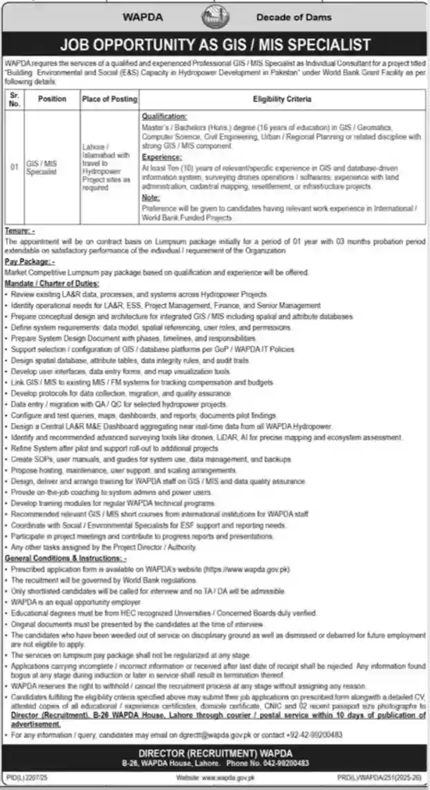
ToggleThe Water and Power Development Authority has opened new employment opportunities for skilled professionals in Pakistan under its hydropower development projects. The latest recruitment focuses on hiring a qualified GIS / MIS Specialist who can support data management and mapping systems required for ongoing and upcoming projects.
Hydropower projects involve land acquisition, environmental monitoring, infrastructure development, and resettlement processes. All these activities require accurate geographic data and reliable information management systems. Because of this, WAPDA is looking for professionals who have strong technical expertise in Geographic Information Systems and Management Information Systems.
For experienced professionals working in GIS, surveying, mapping, or data system development, this recruitment presents a valuable opportunity to work with one of Pakistan’s largest public sector organizations.
This article explains all major details, including eligibility requirements, job responsibilities, contract terms, and how to apply.
Introduction to the Job Opportunity
WAPDA is currently executing multiple hydropower projects across the country. These projects require modern digital systems for mapping, land record management, compensation tracking, and environmental monitoring.
To manage this data efficiently, WAPDA plans to strengthen its GIS and MIS platforms. The selected GIS / MIS Specialist will help develop and maintain data systems that support decision-making at project management levels.
The job requires a professional who can work both in office environments and at project sites when required. The candidate will collaborate with technical teams, environmental experts, and project managers.
This role is suitable for candidates who already have substantial experience in GIS systems and infrastructure development projects.
Required Educational Qualification
Applicants must possess at least sixteen years of education in relevant disciplines. Educational background should align with GIS, information systems, or engineering fields.
Accepted degrees include:
GIS or Geomatics
Computer Science or Information Technology
Civil Engineering
Urban or Regional Planning
Environmental or infrastructure planning with GIS specialization
Any related discipline involving GIS or MIS components
All degrees must be from universities recognized by higher education authorities. Additional certifications in GIS software or database management may provide extra advantage during recruitment.

Experience Requirements
Experience is the most important factor for this position. Candidates must have a minimum of ten years of relevant professional experience.
Relevant experience areas include:
GIS mapping and spatial data management
Development of database-driven information systems
Drone or remote sensing data handling
Land records and cadastral mapping
Infrastructure project mapping and data systems
Environmental and social monitoring platforms
Preference may be given to professionals who have worked on projects funded by international development organizations such as the World Bank or other donor agencies.
Candidates should be comfortable managing complex data systems and supporting large-scale infrastructure programs.
Job Responsibilities and Duties
The GIS / MIS Specialist will perform a wide range of technical and managerial tasks. Responsibilities involve both system development and operational support.
GIS System Design and Implementation
The specialist will work on building and improving GIS and MIS systems across hydropower projects. Tasks include:
Reviewing existing data systems used in projects
Designing improved GIS and MIS architecture
Managing spatial databases and project data
Setting up user roles and system permissions
Creating dashboards and reporting tools
Ensuring system security and performance
The aim is to create efficient systems that provide accurate and real-time data to project teams.
Field Data Management and Technical Support
The job also requires coordination with field survey teams. The specialist will help manage data collected from project locations.
Responsibilities include:
Supporting field data collection processes
Managing data migration from surveys
Conducting data quality checks
Supporting mapping through drones or LiDAR technologies
Assisting ecosystem and land assessments
This ensures accurate information is available for planning and monitoring project progress.
Training and Capacity Building
To ensure long-term sustainability, the specialist will train WAPDA staff in handling GIS and MIS systems.
Tasks include:
Conducting staff training sessions
Preparing manuals and technical guides
Coaching system administrators
Supporting technical teams during system use
Training allows project teams to operate data systems efficiently even after project completion.

Contract Terms and Salary Package
The appointment will be made on a contract basis. Initially, the contract period is expected to be one year, including a probation period.
Contract extension depends on performance and project requirements. Candidates showing strong performance may continue working on extended assignments.
Salary package will be competitive and offered as a lump sum based on qualification and experience. Experienced professionals may receive attractive compensation according to market standards.
Work Location and Travel Requirements
The selected candidate may be posted in Lahore or Islamabad. However, regular visits to project sites may be required depending on project needs.
Hydropower projects are often located in remote areas, so candidates should be comfortable traveling and working in field environments when needed.
Professionals seeking office-only roles may find this job challenging, but those who enjoy project-based work may find it rewarding.
Application Procedure for WAPDA Jobs 2026
Candidates interested in applying must follow the official recruitment procedure.
General application steps include:
- Obtain the application form from the official WAPDA website.
- Fill out the form carefully with complete academic and professional details.
- Attach copies of academic certificates and experience letters.
- Include CNIC, domicile certificate, and recent photographs.
- Submit the application before the deadline at the recruitment office.
Incomplete or late applications are usually rejected. Candidates should double-check documents before submission.
Only shortlisted applicants are contacted for interviews. No travel allowance is normally provided for interviews.
Benefits of Working with WAPDA
WAPDA offers opportunities to work on major national infrastructure projects. Employees gain exposure to advanced technologies and international project standards.
Working in hydropower development allows professionals to contribute to energy production and national progress.
Benefits include:
Experience in large-scale projects
Exposure to modern mapping technologies
Competitive salary package
Career growth opportunities
Professional networking
For professionals planning long-term careers in GIS and infrastructure development, such roles add strong value to professional profiles.
Ideal Candidates for This Job
This opportunity is best suited for professionals who have already worked in GIS or MIS environments and want to advance their careers.
Suitable candidates include:
GIS analysts and specialists
MIS professionals in development projects
Survey and mapping experts
Engineers or planners with GIS knowledge
Data management professionals in infrastructure projects
Fresh graduates or candidates without relevant experience may not qualify because of strict experience requirements.
Common Application Mistakes to Avoid
Applicants often lose opportunities due to simple errors. Candidates should avoid:
Submitting incomplete forms
Providing incorrect information
Missing required documents
Sending applications after deadline
Submitting unclear copies of certificates
Careful preparation increases chances of shortlisting.
Quick Job Summary
Organization: WAPDA
Position: GIS / MIS Specialist
Project Type: Hydropower Development
Location: Lahore / Islamabad with site visits
Education: Minimum 16 years education
Experience: At least 10 years required
Job Type: Contract basis
Salary: Market competitive
Application Mode: Official submission
Conclusion – WAPDA Jobs 2026
WAPDA Jobs 2026 for GIS / MIS Specialist provide an excellent career opportunity for experienced professionals who want to work on national infrastructure projects. Hydropower development requires modern data management systems, making GIS and MIS professionals essential for project success.
The role offers professional exposure, competitive compensation, and involvement in large-scale development initiatives across Pakistan.
Professionals who meet eligibility requirements and possess strong GIS and information system experience should consider applying before the deadline.
With careful preparation and accurate documentation, candidates can improve their chances of securing this rewarding opportunity in one of Pakistan’s leading public sector organizations.
